(CNN) — Another powerful storm, known as a bomb cyclone, is hitting the California coast and the National Weather Service in the Bay Area is warning residents that the "truly brutal" system needs to be taken seriously.
The system could trigger "immediate disruption to commerce, and the worst of all, likely loss of human life," forecasters say. It comes on the heels of a round of record-breaking rainfall that slammed the same area over the weekend.
Meanwhile, a major winter storm that brought snow and freezing rain to its colder northern end — and severe storms and tornadoes on its warmer southern end — is still threatening more severe weather as it treks east.
Bomb cyclone takes aim at West Coast
California's latest dangerous storm is the result of a strong "atmospheric river" — a long, narrow region in the atmosphere that can carry moisture thousands of miles. Northern California and the Bay Area will see the worst impacts through the day Wednesday and Thursday as heavy rain and hurricane-force wind gusts move onshore.
The storm became a bomb cyclone Wednesday, after it rapidly strengthened while still offshore. A bomb cyclone is an area of low pressure that intensifies by 24 millibars within 24 hours. Millibars are a unit used to measure atmospheric pressure.
Along with very heavy rainfall, winds gusting as high as 60 to 80 mph will be possible.
"If these winds do materialize, the threat for scattered to widespread power outages and property damage will greatly increase," the weather service office in San Francisco warned.
"A plethora of hazards are forecast, with heavy rain and strong winds expected to be the most widespread impact. Widespread rainfall amounts of 3 to 6 inches are anticipated, with locally higher amounts throughout the coastal ranges and over northern California," the weather service said.
While those expected rainfall amounts wouldn't normally have major impacts, the state recently saw heavy rain that left soil saturated and susceptible to flooding and landslides, the weather service said.
Northern California in particular was inundated with heavy snowfall and deadly flooding over the weekend, prompting evacuation orders and water rescues. That raised questions over how much the precipitation would put a dent in California's ongoing drought conditions.
The first snow survey of the season in the Sierra Nevada Mountains released Tuesday shows the current snowpack is well ahead of average for this time of year, according to a release from the California Department of Water Resources.
The Sierra snowpack makes up about 30 percent of California's water needs on average, according to the department.
The snow depth measured Tuesday at Phillips Station, just south of Lake Tahoe, was 55.5 inches. Statewide, the snowpack is at 174 percent of average for this date, the agency said.
However, experts caution that despite the deluge — and expected precipitation over the coming week — the drought isn't over yet.
"The significant Sierra snowpack is good news but unfortunately these same storms are bringing flooding to parts of California," DWR Director Karla Nemeth said in a news release.
"This is a prime example of the threat of extreme flooding during a prolonged drought as California experiences more swings between wet and dry periods brought on by our changing climate."
And the stormy weather isn't going to let up anytime soon. More rain is expected through the weekend, though the specific impacts aren't clear yet.
"The message to convey is resiliency as this is not a 'one and done' storm," the weather service in San Francisco said.
Tornado-producing storms push east
Meanwhile, more than 30 million people are under some sort of severe weather threat in the South, with the risk of severe storms stretching from the Florida Panhandle into far southeast Alabama and parts of Georgia and along the East Coast into southeastern Virginia.
As the showers and storms push into Georgia and northern Florida, damaging wind gusts, large hail and tornadoes are possible.
Cities including Tallahassee, Charlotte, Virginia Beach, Atlanta, Raleigh, and Norfolk could see winds and tornadoes. Heavy rain could also produce flash flooding in parts of the Southeast.
The multi-hazard storm — which headed into the central and southern US after battering California with deadly floods — has already triggered at least 130 storm reports over the past two days and left a trail of destruction as it barreled across the country, shifting to the South and Southeast.
There have been more than a dozen tornado reports, nearly 100 wind reports and 27 hail reports. The tornado reports included six in Illinois on Tuesday and an EF-1 in Jessieville, Arkansas, on Monday. An EF-1 tornado packs winds of 86 to 110 mph.
Other tornado reports came from Louisiana, Oklahoma, Tennessee, Georgia, and Mississippi.
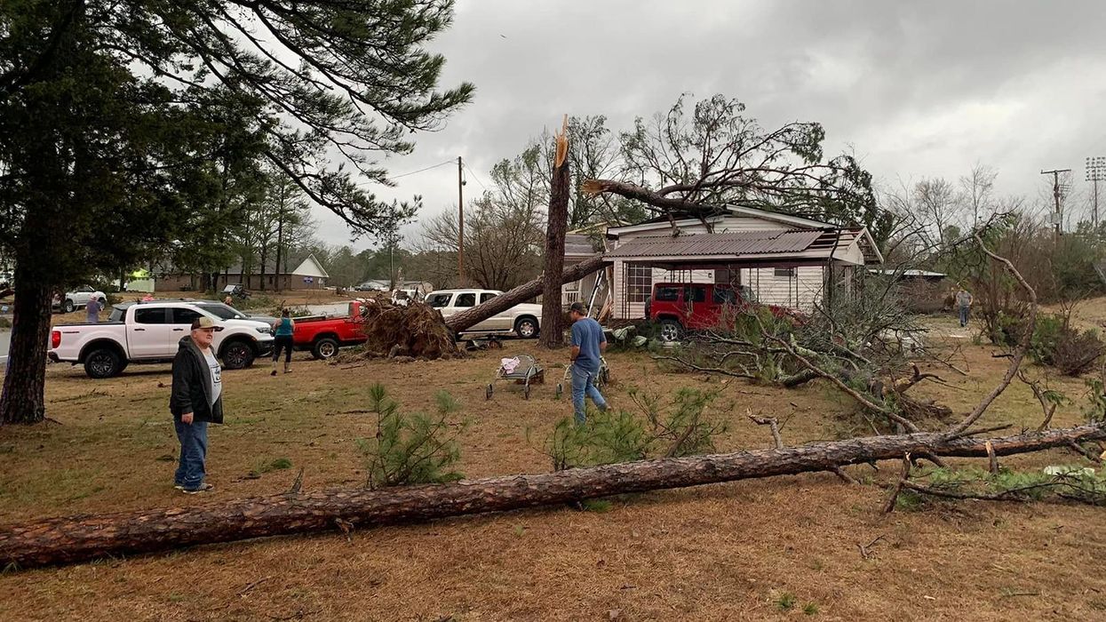
Police in Montgomery, Alabama, were dispatched throughout the night to "multiple locations" in the city in response to "reports of damage due to [a] possible tornado," the city said Wednesday. More than 50 homes and businesses were damaged following the severe weather overnight, said Montgomery Mayor Steven L. Reed.
There were no fatalities, but one adult with a minor injury was reported, the mayor said.
"It could have been so much worse," Reed said. "We have to make sure that we're taking these things seriously and that we understand that, in this time and in this area, we're going to see more these events."
A possible tornado touched down in Burke County in eastern Georgia on Wednesday, downing trees and causing damage to some homes and power lines, the Burke County Sheriff's Department said. Another possible tornado struck just south of Atlanta, in the same neighborhood that was hit by a powerful tornado in 2021.
The storm also brought heavy rain, with much of the South seeing 48-hour rainfall totals between 2 to 4 inches. Some areas across the Mississippi and Ohio River Valley saw up to 6 inches, and isolated areas across eastern Arkansas got 10 inches.
In Tennessee, Memphis and Jackson both saw record-breaking rainfall on Tuesday. Memphis received 3.84 inches, smashing its previous daily record of 2.13 inches set in 1949. Jackson got 2.48 inches on Tuesday, beating the previous daily record of 1.69 inches in 1951.
An extremely warm and moist air mass over the East Coast and Southeast helped fuel the severe weather outbreak. Over 35 daily high temperature records were broken across the eastern US on Tuesday, with the thermometer hitting 81 degrees in Baton Rouge, 77 degrees in Wilmington and 69 degrees in Washington, DC.
Meanwhile, over 5 million people are under winter weather alerts across the Upper Midwest and Great Lakes, where snow and ice accumulations are expected to affect travel, according to the weather service.
Heavy snow is expected across parts of the Upper Midwest through Wednesday, while freezing rain and a wintry mix will spread into northern New England by Thursday, the weather service says.
The storm is expected to gradually begin dissipating Thursday.
The-CNN-Wire
™ & © 2023 Cable News Network, Inc., a Warner Bros. Discovery Company. All rights reserved.
- Over One Million Without Power Due to Harsh Winter Storms ›
- The Places That Received the Most Snow in the Winter Storm ›
- Winter Storm Death Toll Rises to 34 in Buffalo, New York ›
- Is Climate Change Making a White Christmas Less Likely? ›
- Harsh Winter Storm Puts Migrants at Risk ›
- 'Once in a Generation' Winter Storm Will Impact Nearly Every State ›
- 90 Percent of California Under Flood Watch as Winter Storm Worsens - Advocate Channel ›