(CNN) — Tropical Storm Nicole has gotten stronger -- with scattered showers impacting parts of Florida on midterm Election Day -- and is expected to strengthen more before slamming the state's east coast early Thursday as the first hurricane to strike the United States in November in nearly 40 years.
Hurricane warnings remain in effect Tuesday for parts of Florida ahead of Nicole's expected landfall early Thursday morning north of West Palm Beach as a Category 1 hurricane with torrential rain and damaging winds, as many across the state continue to endure the aftermath of Hurricane Ian.
"#Nicole is a formidable storm that will have major impacts all along the southeastern U.S. coastline, not only near the center. Coastal flooding, large waves and rip currents will extend from the tip of FL to NC," the National Weather Service tweeted.
Nicole was very close to hurricane strength Tuesday night, with 70 mph sustained winds, and is expected to become a hurricane -- meaning sustained winds of at least 74 mph -- overnight. At 10 p.m. ET, it was about 325 miles east of West Palm Beach and moving west-southwest at about 10 mph.
Nicole's tropical storm-force winds extend 380 miles from the center and are expected to be felt in Florida beginning late Wednesday morning.
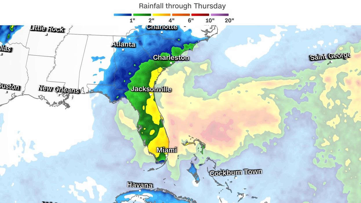
Nicole is then due to produce heavy rain that could lead to dangerous storm surge and high winds Wednesday, said Jamie Rhome, the acting director of the National Hurricane Center.
It is projected to be a strong tropical storm or a Category 1 hurricane -- with sustained winds of at least 74 mph -- by the time it reaches Florida Wednesday evening into Thursday morning, Rhome said Monday in a video briefing posted online.
Up to 7 inches of rain and storm surge that could rise up to 5 feet along the coast, combined with high winds, are mainly forecast for Wednesday evening and Thursday. And because the storm's track shifted west late Tuesday, a storm surge watch is now in effect for the panhandle and some of the west coast, the center said.
"The storm surge will be accompanied by large and damaging waves. Residents in the warning area should listen to advice given by local officials," the hurricane center said.
Orlando International Airport will suspend operations as of 4 p.m. Wednesday "until circumstances permit operations resume," the state's busiest airport said Tuesday afternoon on Twitter.
Palm Beach and Volusia counties have issued mandatory evacuation orders starting Wednesday morning for some residents. In Palm Beach, the order is in effect from 7 a.m. ET for zones A and B and include barrier islands and low-lying areas, according to a release on the county's website.
In Volusia County, home to Daytona Beach, the order is in effect Wednesday at 10 a.m., including those east of the intracoastal waterway or in flood-prone areas, all campsites and RV parks and all mobile and manufactured homes.
"Tropical Storm Nicole poses a direct threat to property and life," County Manager George Recktenwald said on the Volusia County website. "Our infrastructure, especially along the coastline, is extremely vulnerable because of Hurricane Ian's impacts. We expect further erosion along the beach, along with flooding in areas that were previously flooded by Ian. Residents need to take this storm seriously."
Brevard County on Tuesday issued an evacuation recommendation starting Wednesday for some residents, including people on the barrier islands, "including areas from Kennedy Space Center south beaches, and Merritt Island," those in flood-prone areas, mobile and manufactured home residents, and people with special medical needs who are dependent on electricity.
Southeastern Florida is already experiencing some of the highest tides of the year, thanks to this month's full moon. These tides will be pushed significantly higher by Tropical Storm Nicole's approach, creating even higher water levels and more beach erosion for coastal communities on the east coast of the state during the next several high tide cycles, according to the National Weather Service.
The large and strengthening storm is creating a steady stream of onshore winds that will only increase as Nicole gets closer, pushing and piling the water on the shoreline, so that coastal flooding and beach erosion will be possible even before Nicole makes landfall.
"These winds, high seas, and surf will combine with high astronomical tides to bring the threat of significant beach erosion around the times of the next several high tide cycles," said the NWS in Melbourne.
But flooding in the state will not be limited to the immediate coastline, as heavy rainfall will lead to freshwater flooding well inland as well.
The St. John's River in Florida still remains at Moderate Flood Stage from Hurricane Ian. Nicole's passage and the resulting rainfall is expected to cause the water to rise once again on this slow-moving river, creating flooding concerns once again.
"Levels are forecast to reach Major Flood Stage at 4.0 feet once again on Friday, remaining steady into the weekend. A higher rise is possible depending on rainfall totals as well as the northerly wind surge leading to a backup of water on Lake George," the NWS said.
More than 5 million people are under a storm surge warning from North Palm Beach, Florida, north to Altamaha Sound, Georgia, including the mouth of the St. Johns River to Georgetown.
The storm is not expected to intensify rapidly like Ian did in late September before killing at least 120 of people in Florida and destroying communities still reeling from the destruction. No hurricane has hit the US in November since Hurricane Kate struck Florida as a Category 2 in 1985.
"We're not forecasting a major hurricane," Rhome said. "Again, not an Ian situation, but still a potentially impactful system."
Nearly 2 million people are now under a hurricane warning that extends from Boca Raton to the Flagler-Volusia County line; a hurricane watch runs north from there to Ponte Vedra Beach.
Nearly 15 million people are under a tropical storm warning -- with conditions expected in the zone within 36 hours -- from Hallandale Beach, Florida, north to Altamaha Sound, Georgia, plus Lake Okeechobee in southern Florida. And along the state's west coast -- from north of Bonita Beach to the Ochlockonee River -- places slammed by Ian are now under tropical storm watches.
A tropical storm watch was issued Tuesday for north of Altamaha Sound in Georgia to South Santee River in South Carolina, and a storm surge watch was issued from the Savannah River to the South Santee River in South Carolina and from the Suwannee River to the Ochlockonee River in Florida.
A storm surge watch is in effect on the west coast along the Florida panhandle from the Ochlockonee River to Indian Pass, the hurricane center said late Tuesday.
The mayor of Miami-Dade County urged residents to prepare for the storm.
"Residents and visitors should monitor the forecast and make sure their storm kit is up-to-date," Mayor Daniella Levine Cava said online. "We're taking all needed precautions to prepare for potential flooding and power outages."
Miami-Dade County officials are not expecting the storm to impact Election Day, Levine Cava said.
The-CNN-Wire
™ & © 2022 Cable News Network, Inc., a Warner Bros. Discovery Company. All rights reserved.
- Subtropical Storm Nicole is on track to strengthen into a Category 1 ... ›
- Tropical Storm Nicole, on the cusp of Cat 1 strength, nears Florida ... ›
- Tropical Storm Nicole to Reach Hurricane Strength as It Heads ... ›
- Tropical Storm Nicole to become a hurricane ahead of Florida ... ›
- Tropical Storm Nicole is on track to strengthen into a Category 1 ... ›